TURNPIKE ROADS IN RASTRICK
This is a study by John Sheppard of Rastrick, a member of the Rastrick Local History Group & Friends of Rastrick Library, who has researched the subject of the Turnpike Roads that travelled through the township of Rastrick in the 19th century.
TURNPIKES IN RASTRICK
Turnpikes were literally pikes (or bars, chains or gates) which could be turned open or closed to allow or obstruct the passage of traffic. Turnpike trusts were bodies set up by individual Acts of Parliament, with powers to collect road tolls for maintaining the principal roads in Britain from the seventeenth but especially during the eighteenth and nineteenth centuries. From a slow start, this system was greatly expanded in the 1750’s and ’60’s. However, toll roads, initially trumpeted as a great way to secure the improvement of highways, fell into disrepute as it became all too obvious that the trusts, mostly debt-ridden, were more interested in generating income than in maintaining roads. The system was generally abolished in the 1860’s and ’70’s, with the last remaining turnpike trust abolished in 1885. Under the provisions of the Highways Act of 1878 all “disturnpiked” roads became “main roads”, as did also some ordinary highways. By the Local Government Act of 1888 the entire maintenance of main roads was thrown upon the County Councils.
Four turnpike roads were constructed through Rastrick. Each of these is still a main road. They are, in current nomenclture:
Clough Lane – Dewsbury Road;
Crowtrees Lane – New Hey Road;
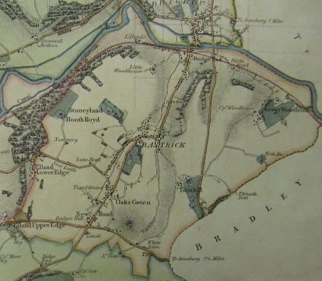
Huddersfield Road;
Bridge End – Rastrick Common – Tofts Grove – Lower Edge Road.
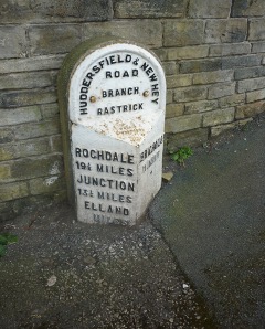
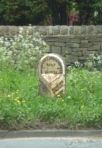
Turnpike trusts were obliged, through their individual Acts of Parliament, to measure the roads and erect markers at one statute mile intervals indicating the distance to the towns at the end of the road, though it is said that not all fulfilled their obligations in this respect. Two iron milestones remain on Rastrick turnpike roads but in fact these are 1890’s replacements made by Brayshaw and Booth of Liversedge for the new county council. A similar marker which stood beside New Hey Road disappeared when the motorway was built. There is also the stone guidestone at the junction of Tofts Grove and Delf Hill, dated 1737 which was probably placed there by the township
DEWSBURY – ELLAND
An “Act for Repairing and Widening the Road from Dewsbury to Ealand” was passed in 1759. The turnpike road followed the established route from Fixby to Upper Edge but avoided what for wheeled traffic had become a customary diversion via Cote Lane and Pinfold Lane. This was twenty-four years after the turnpike from Blackstone Edge to Halifax and Elland, but it was nevertheless a comparatively early turnpike road. It was run by the Dewsbury and Elland Trust and is marked as such on the 1854 map. The “Rastrick Turnpike” (i.e. the gate where tolls had to be paid) is marked on the first edition of the Ordnance Survey map, surveyed between 1839 and 1841, and is apparently at the junction of what are now Clough Lane and Lightridge Road. Unemployment relief works in 1827 are thought to have allowed the easing of gradients at Badger Hill by the construction of an embankment and a cutting. As was the general custom, the franchise to collect tolls was from time to time let by auction.
HUDDERSFIELD and NEW HEY TURNPIKE – BRIGHOUSE BRANCH
In 1806 authority was given for a turnpike road to be built between Huddersfield and New Hey (near Rochdale), together with a branch from Outlane towards Brighouse. This involved the construction in Rastrick of a completely new road straight up from Top o’ Town, thus by-passing the old route which went by way of Tofts Grove, Delf Hill and Slade Lane. According to the Leeds Mercury, the New Road (sic) cut “by way of Rastrick through the manor and estates of Thomas Thornhill, Esq. Of Fixby, and principally at his expense.”
In July 1809 there were advertised for sale “A close of ground called The Common Field, in the occupation of Daniel Dyson, now divided into two fields by the new turnpike road leading from Rastrick to Manchester; two other closes called Fletcher Lands in the occupation of Wm. Garlick, one of which is divided by the said road; a croft in the occupation of Jonas Wilkinson, also divided as above”.
The new road, opened on 1st August 1809 was officially the Outlane and Rastrick Branch of the Huddersfield and New Hey Trust and is marked as such on the 1854 map. A turnpike is shown by the then row of cottages at Ridge End (approximately where now the footbridge from Pinfold Lane crosses the motorway). The census of 1861 identifies Thomas Ambler, a quarryman, and his wife Selina, together with their five children, as resident at Ridge Bar House – bar keeper is not mentioned but probably this was a family duty conducted mainly by Selina when Thomas was at the quarry. In the 1871 census, Joseph Wilkinson of Ridge End is described as a toll collector.
There was also, in 1859, a proposal to add a bar at Oaks Green but this seems to have come to nothing as later notices do not mention it. In the case of the New Hey road, tolls were still advertised as available to let in 1873, but notices dated June and August 1874, which call for particulars of claims on the board, seem to be the last official notices issued by that board, suggesting that this is when the trust was wound up.
Now officially known as New Hey Road, this road is generally referred to as New Road, which is not only an abbreviation of its formal name but probably also a reflection of its comparatively recent introduction. The Sun Inn, strategically built at the crossroads of two turnpikes, is thought to have been built in 1806 and has certainly been in operation since 1822, or earlier, when a John Bell was running the pub.
LEEDS – ELLAND TURNPIKE
The road from Rastrick Bridge over Lower Edge was improved by the Brighouse and Elland Trust in 1814-5. Tolls were abolished in 1868.
HUDDERSFIELD – BRADFORD TURNPIKE
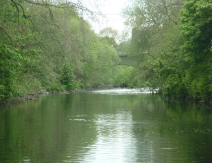
In 1823-4 a further new road was built from Huddersfield to Bradford, officially The Wibsey, Low Moor and Huddersfield Turnpike. It was quite late in the history of turnpike trusts, of which the last were established in 1835-6. This included the construction of a new bridge over the River Calder. The proposal was advertised in the Leeds Mercury in March 1823 giving the route through Rastrick as “…in a south-easterly direction to the corner of Hilly Wood and from thence unto or near to a place called Toothill, within the Parish of Halifax, and from Toothill, through Fellgrove Wood, to Cuckold’s Clough…”
The route from Brighouse and Rastrick to Huddersfield had hitherto been via Rastrick Common, Toothill Bank and Shepherds Thorn Lane so this new road was cutting the distance considerably and easing gradients. In August 1823, a notice in the same newspaper sought tenders “for the erection of two stone, cast iron or chain bridges over the Canal and the River at Brighouse, of one or more arches,” and later the same month for “the forming, making, stoning and fencing of such part of the intended new turnpike road from Wibsey Low Moor, near Bradford to Huddersfield, as lies between the Friends’ Meeting House, near Brighouse, and the Hebble Bridge, near Huddersfield.”
The bridge was opened in 1825. The first meeting of the trustees was held at the end of June 1830, suggesting that the road had been some time in completion. Toll collection points were established at Brighouse Bridge and, beyond Rastrick, at Bradley Bar. The precise description – chain, bar or gate – varied from one year’s let to the next. This turnpike trust was abolished on 31st October 1875. By 1907 the section through Rastrick was known simply as Huddersfield Road.