HISTORIC PHOTOGRAPHS OF THE CALDER & HEBBLE NAVIGATION BETWEEN BRIGHOUSE AND ELLAND
FANTASTIC OLD PHOTOS TAKEN ON THE CANAL BETWEEN BRIGHOUSE AND ELLAND WITH SOME ADDITIONAL HISTORICAL NOTES
INTRODUCTION
This is a series of photographs taken along the Calder & Hebble Navigation between Brighouse and Elland. It was called the Navigation because the river was made navigable wherever possible and where it wasn’t possible to use the river, canal sections were built to by-pass the numerous obstructions.
The presentation includes many photographs from the old section of canal which ran at the bottom of the woods below Rastrick, known as Tag Cut. There are some interesting pictures, some of which were kindly forwarded to me by Phillip Whitaker, who I thank for his contribution. I hope you enjoy this historical ride into the past.
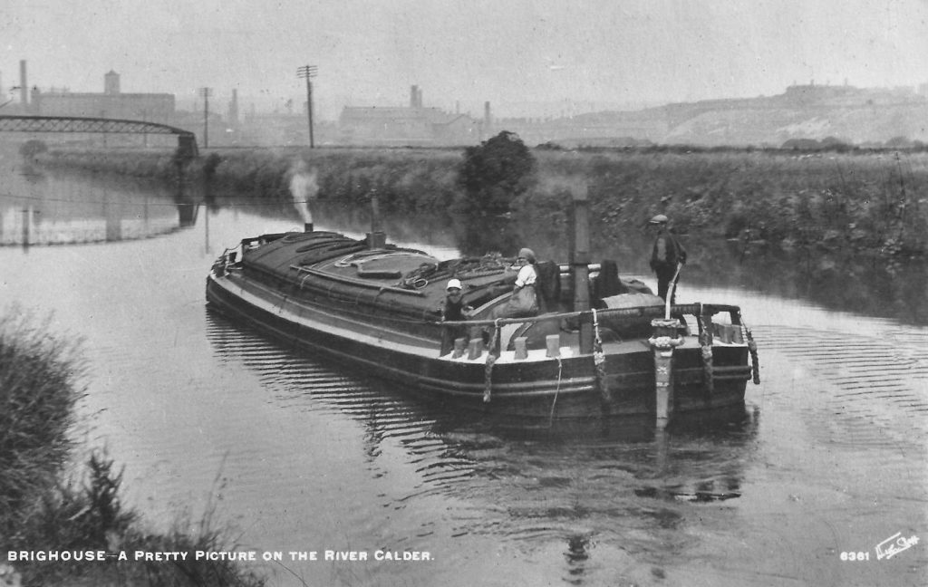
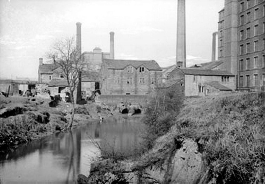
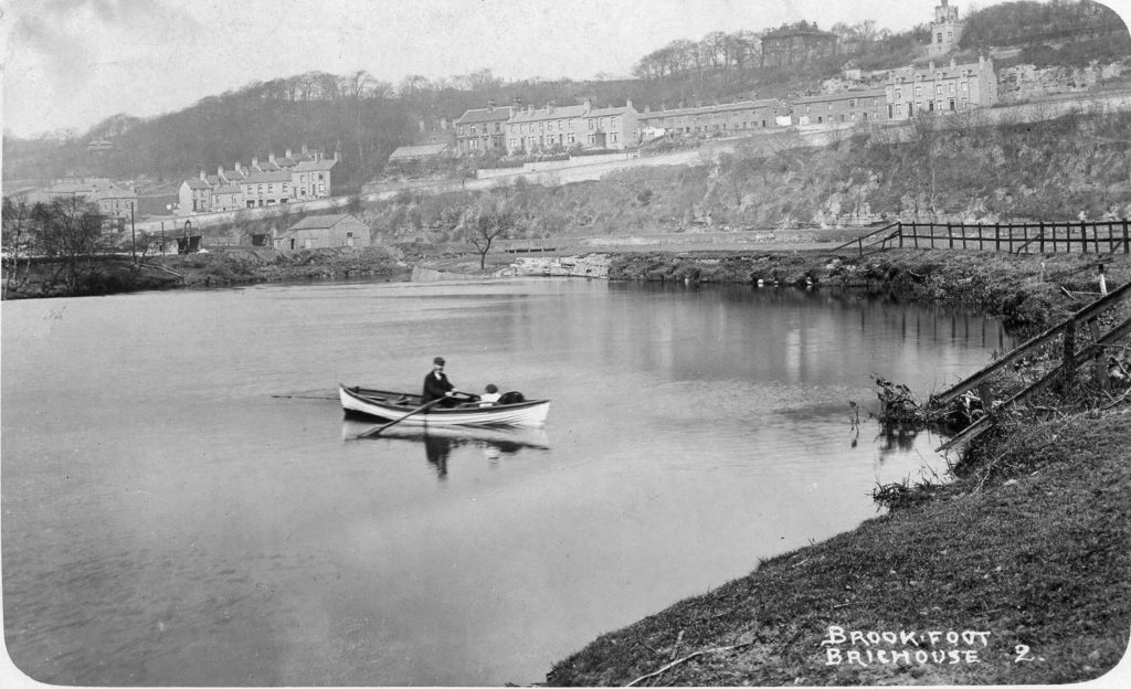
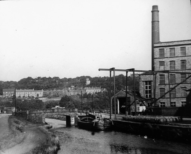
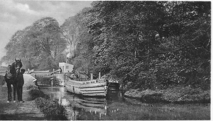
We start this journey to Elland by travelling up the River Calder from Anchor Pit on the above photograph. In the distance is George Street Mill with its central tower that helps to identify it on many old photos. The land to the right is now the Armytage Road Industrial estate but was formerly agricultural land. To the left, but out of view was River Street and the famous Blakeborough Valves company at Woodhouse Works.
Look carefully at the vertical towing mast positioned on the front right of the boat. You can just make out the tow-rope, especially where it passes by the white smoke. It leads towards the left hand banking where the towpath travelled to and from Brighouse. Canals and rivers only ever have a single tow-path situated on one side of the navigation. The tow-rope was usually 85 feet in length and so the horse would be a few yards ahead of the boat. Due to the towing angle, the horse would be pulling the boat in towards the banking and so the bargee had to steer the rudder to the right so that the vessel travelled in a straight line. You can see the angle of the rudder at the rear of the boat.
Because of the towing angle, the horse walked very close to the edge of the tow-path and if the barge hit a hidden obstacle in the water, causing it to stop suddenly, the momentum could pull the horse backwards into the water. Every so often, escape routes were built into the banking so that the horse could be led back onto dry land.
After travelling along the tow-path at the rear of several industrial premises located off Birds Royd Lane, vessels arrived at the flood lock gates which lead into the canal basin at Brighouse Low Lock. Because the entrance into the basin is on the opposite side of the river, a bridge was necessary for the horse to cross from one side to the other but this wasn’t built until 1838. Prior to that, the horses had to be led further upstream and then across the river at the ancient Snake Ford, before linking back with their boats on the opposite side. When the bridge was built, there was a charge of a half penny or a ha’penny as it was called in these parts. The toll was payable at the toll booth, which on the photograph, is the small building with a chimney on the opposite bank.
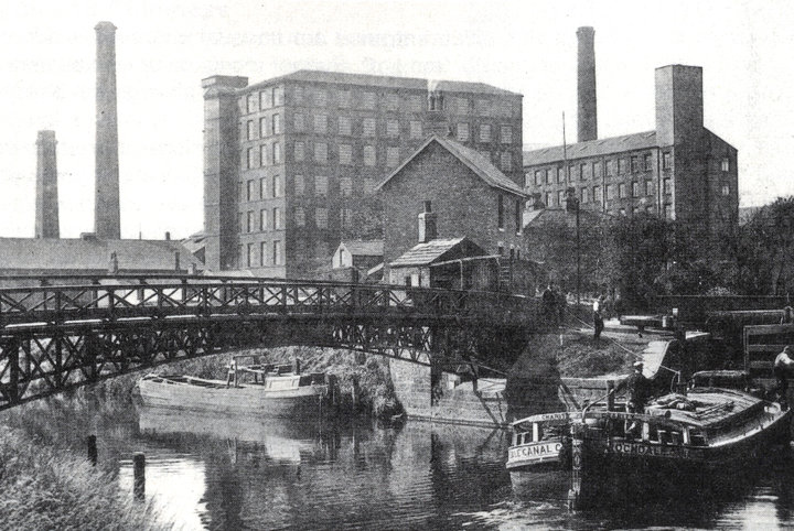
Beyond the bridge is Mill Royd Mill (now converted into Mill Royd Island apartments) on the left and Victoria Mills to the right (where Sainbury’s supermarket now stands). In the photo, a barge is waiting to pass through the lock gates and enter the canal basin. The barge is from Rochdale and will be heading up the Calder & Hebble to Sowerby Bridge where the canal links with the Rochdale Canal.
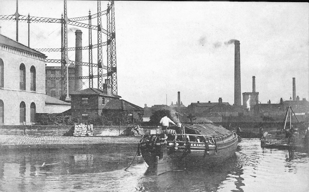
The next photo above shows barges in the Canal Basin at Brighouse with the old gasworks on the left and the opposite side of George Street Mills to what we saw previously, with its chimney visible through the framework of the gasometer. The barge is heading out of the Basin towards the River Calder and will then be heading along the river to Anchor Pit and Wakefield where canal traffic would then join the Aire and Calder Navigation in order to head out to the port at Goole or to the east coast at Hull.
If you look closely to the right of the front of the barge, you can make out the lock gates through which canal boats entered and exited the river and looking even closer, you can just make out the rope which a man, standing on the canal side is holding. The photo is quite blurred but you can just see the horse with its white fetlocks to his right. The man will be attaching the rope to the horse, which will then haul the boat along through the water.
In the background are the Calder Dyeworks, Tower Dyeworks, Calder Wire Works, the Malthouse and other buildings located on the opposite side of the Calder, on Foundry Street off Birds Royd Lane. The square tower with turrets and a chimney is the Red Cross Brewery owned by Brook & Booth brewers. They supplied many pubs in Brighouse and Rastrick including the Vulcan which was located straight across the road from the brewery. It was taken over by Saml. Webster’s of Halifax soon after the Vulcan closed its doors in 1926. I have only ever seen a drawing of the brewery before and this is the first photograph I have ever seen of it.
Upon leaving the Canal Basin, the towing horse would cross over Ha’penny Bridge and make it’s way along the towpath in the opposite direction to the first photograph. Ha’penny Bridge was swept away during a flood in September 1946 and was never replaced as by that time, most barges were driven by mechanical power.
A quick explanation as to why the canal had to cut through Brighouse is because of the two weirs located on the river, which can be seen from either side of the Huddersfield Road bridge. The weir nearest to the Rastrick Bridge created a deep head of water at the upstream side of it and the wide river flow was forced into a small run-off channel which passed under the mill and rotated the waterwheel which in turn drove the machinery inside Sugden’s Flour Mill (pictured above left after a major fire in 1895). The small arch to the right of the photo is where the water flowed back into the river having completed its job of creating water power.
The weir on the eastern side of the bridge worked in a similar way and ran below the Brighouse Low Mill, an ancient textile fulling mill dating back to 1478 (pictured above right). From 1571 it was owned by the Armytage family, latterly of Kirklees Hall and was sold by that family to the Calder & Hebble Navigation Company in 1816. It was demolished in 1887 and the modern Mill Royd Mill can be seen to the right of it. Again, two arched tunnels are visible from which the river flowed as it continued its journey eastwards.
Following the 1895 fire, a new mill was erected by Sugden’s in a similar style to the old one and it still stands to this day. The ‘long gone’ houses on Briggate can be seen between the mill and Naylor’s coal merchants building whilst the weir, Rastrick Bridge and the rear of the Duke of York pub at Bridge End can be seen to the left with Thornhill Road and Lillands above the railway embankment wall.
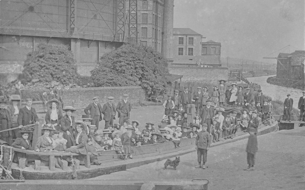
Returning to the canal basin, the above photograph shows that barges were not just used for the transportation of goods but were often temporarily converted into passenger carrying pleasure craft. Hats were certainly the order of the day in Edwardian Britain as there are no more than four or five people without a head covering of some kind. The ladies have an array of fashionable hats that could never possibly return to being ‘in vogue’….. or could they? The younger girls are mainly sporting straw boaters whilst the men and boys are all wearing an assortment of cloth caps. Nearly all of the boys are wearing Eton collars, so called because they imitated the school uniform of the upmarket Eton College, whilst the men are in collar and tie, suits with waistcoats adorned with gold watch-chains that were usually given by parents on their son’s 21st birthdays. My guess is that it is an outing from one of the local churches or Sunday Schools. The boat is positioned between the two gates in the Lower Lock and a man is visible on the left, holding the tiller, which suggests that the barge is about to enter the River Calder and head downstream.
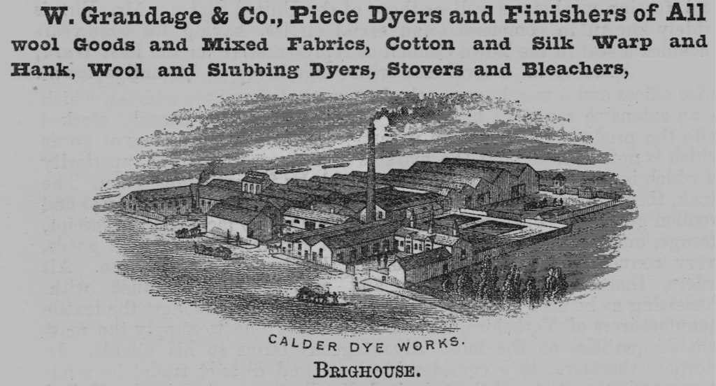
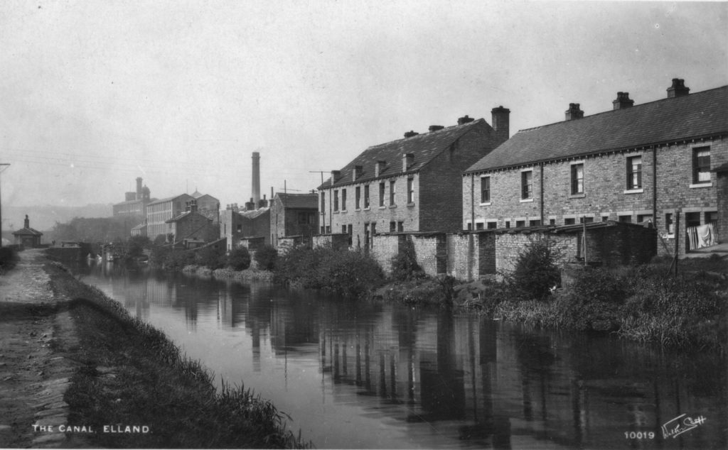
The gasworks and George Street Mill are in the background whilst the towpath and Calder Dye Works are visible on the opposite bank. The dye works has a huge crane protruding from the building and appears to have a landing jetty against the canal bank which suggests that the company was very reliant upon the waterway for transporting their products.
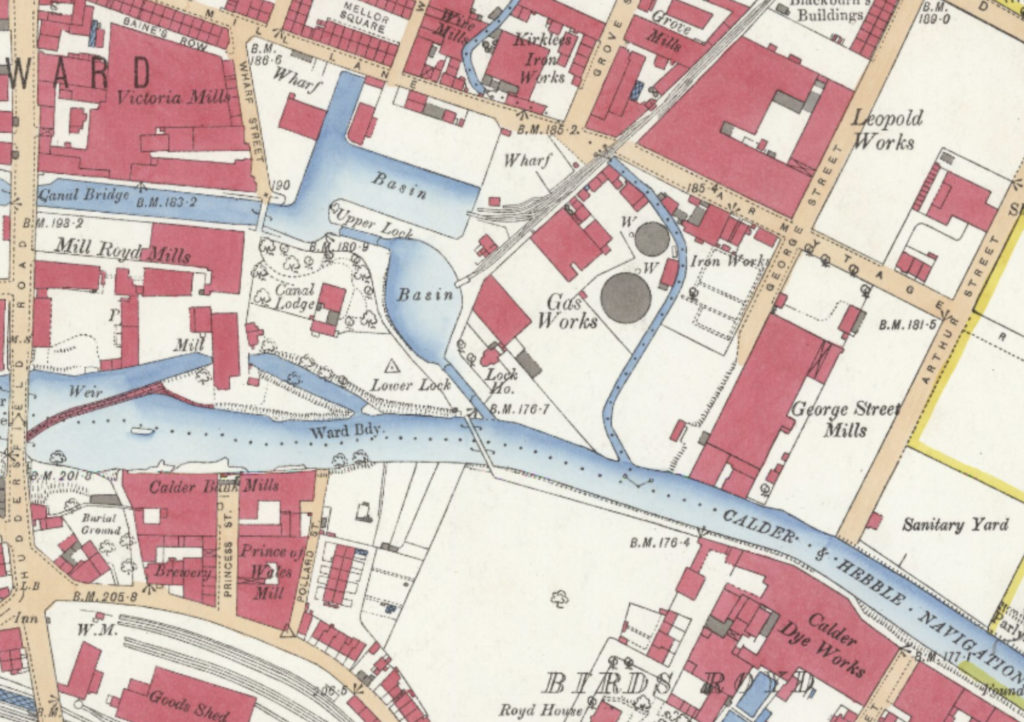
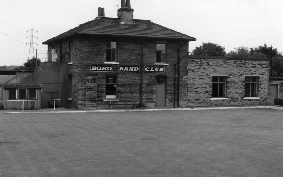
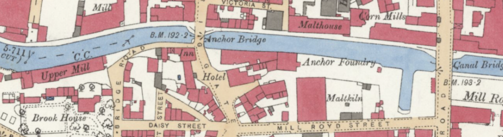
The above map shows the area around the canal basin with the lock gates on the Lower Lock and Upper Lock depicted with a small line across the waterway. The map illustrates how the Calder was diverted through the Brighouse Lower Mill to drive the waterwheel. It also shows the footbridge across the Calder with the towpath running behind the Calder Dye Works. The Canal Lodge is shown in a tree lined garden, this building later became the Borough Band Club where the garden was replaced by a crown green bowling area, shown in the photograph below. Sadly, this building was also demolished and has been left as derelict land for over 20 years.
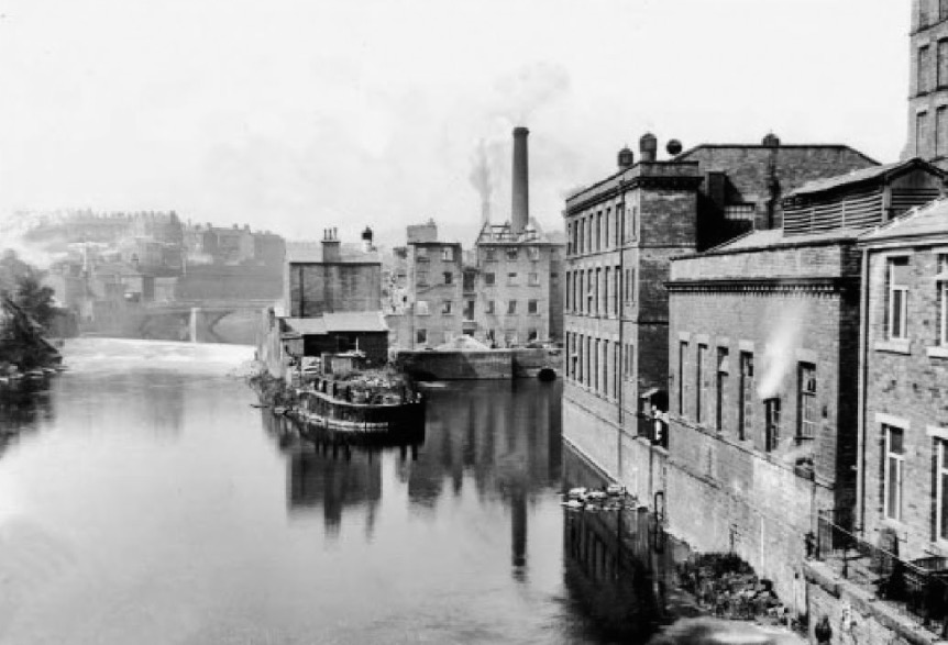
After exiting the canal basin through the Upper Lock, the canal passed between Mill Royd Mills on the left, which was last occupied by Henry Cullingworth’s but has since been converted into apartments known as Mill Royd Island. On the right, where Sainbury’s now stands, was the large complex known as Victoria Mills which consisted of several different buildings between the canal and Mill Lane. The mill was built by the brothers James & Henry Noble in 1838 and was named Victoria Mill to celebrate the coronation of the new queen who had ascended to the throne during the previous year. It was used by many different companies over the following 150 years but was famous in the 1850’s as having the first fire-engine in the district. The owner at the time was Samuel Baines and the fire engine was named Neptune. Mill fires were quite prevalent and newspaper reports of such events always made reference to Samuel Baines’ engine being the first on the scene. If you return to the top left corner of the above map, you will see that a road named Baines Row ran from Wharf Street off Mill Lane, along the rear of Victoria Mills.
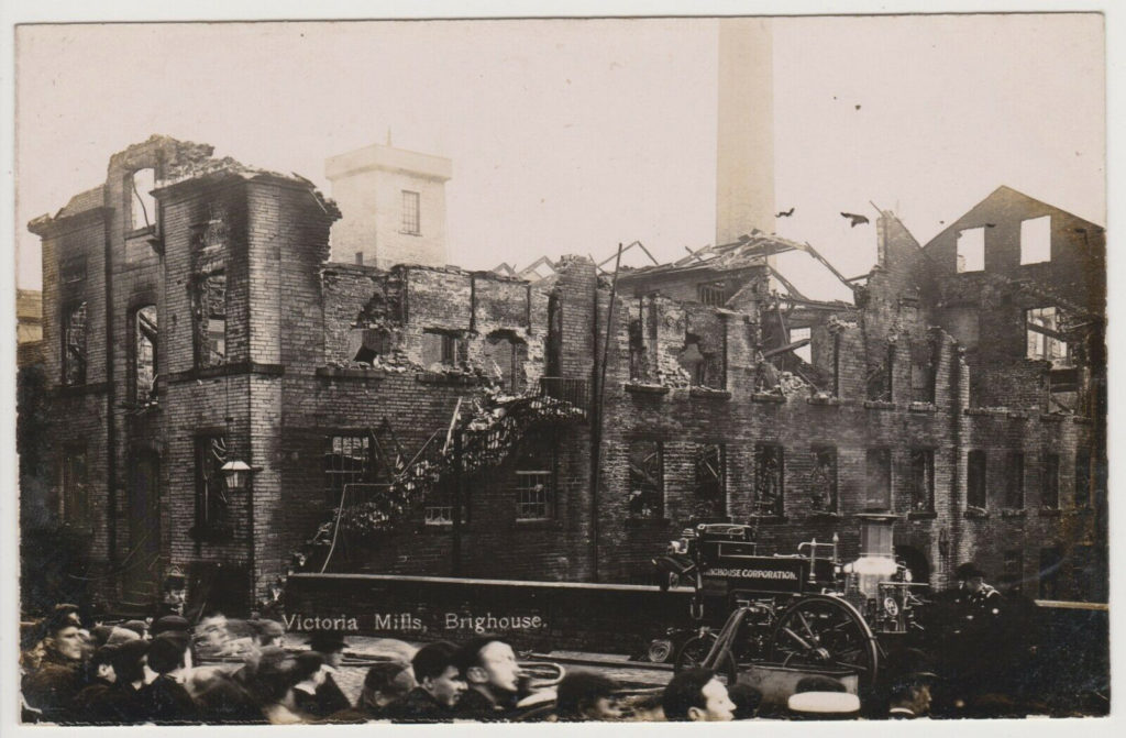
Victoria Mill suffered a large fire in 1896 but there was a more devastating conflagration on the 27th July 1905 as can be seen above. The photo is taken from the canal bridge. People can still walk along this towpath towards the canal basin at this same location. Following the fire, the demolition men were able to save the bottom two storeys of the mill whilst amazingly, all four storeys were saved beyond the gable on the right of the photo.
I remember as a child, waiting with my mother at the number 64 Bradford to Huddersfield bus stop and playing on those steps leading up from the footpath to two large wooden doors inside the arched doorway, which are visible on the left side of the picture. Interestingly, if you look very closely above the policeman’s head, who is standing to the right of the steps, you can just about make out a semi-circular shape that appears to be on the top of his hat. That is the top of a cast iron milestone, which I also remember as a child. When Sainsbury’s was built, a ramp was created leading up from the car park to the current bus shelter, which has a low stone wall. Fixed to the wall in that same location is that very same milestone which has been at that location since about 1890.
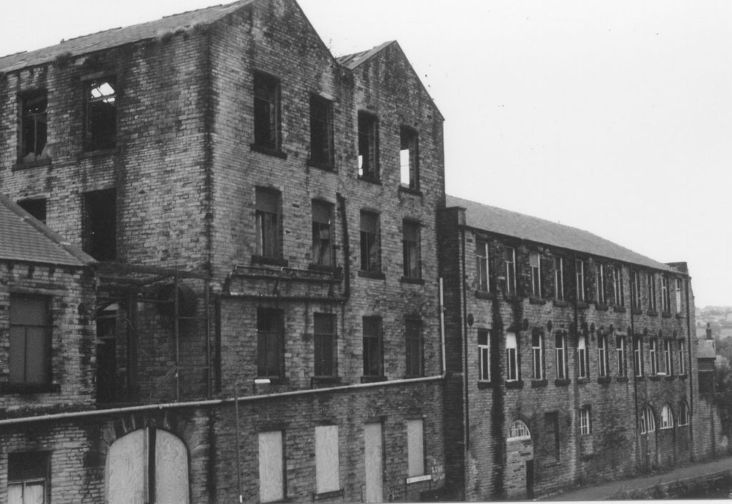
The photograph above was taken by my father just prior to demolition starting in readiness for the new Sainsbury’s supermarket. You can see the four storey section that remained after the 1905 fire and he has just managed to capture the two storey building on the left, which led up to Huddersfield Road.
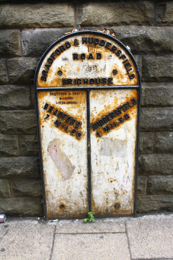
The photograph on the right shows the old milestone which is still at that location, albeit, bolted to a new wall. It was made by Brayshaw & Booth of Liverpool but was probably cast at their foundry in Liversedge, where many of these local milestones (still called ‘stones’ even though they are cast iron), were made.
After passing Victoria Mill, the navigation travels beneath the Huddersfield Road bridge, built in 1823-24 for the Wibsey, Low Moor and Huddersfield Turnpike Road. On the left bank was a wharf with a small basin area where barges could be loaded or unloaded, away from the main canal. On the opposite bank was, and still is, Perseverance Mill which was built in 1831. The mill was built by Thomas Sugden of Bradford who came to Brighouse in 1818 and opened a grocers shop on Briggate. In 1829 Sugden bought a corn milling business from Thomas Sutcliffe. Due to his endeavours, the business thrived and he arranged for the mill to be built, giving it the name Perseverance, reflecting the hard work he had put into achieving success.
The above 1893 map shows the Huddersfield Road bridge with the towpath and Perseverance Mill on the north side of the canal. Another building was later erected between Perseverance Mill and the Malthouse, making one continuous length of industrial premises along the canal between Huddersfield Road and Canal Street. Apart from Perseverance Mill, all the others were destroyed by fire at various times during the 20th century leaving waste ground which now forms the Bethel Street car-park. On the south side of the canal was a grain warehouse, also belonging to Sugden’s. That was also destroyed by fire when I was a young child, I’m guessing about 1964. The walls bulged outwards and then collapsed into the canal and it took months to clear away the debris.
Many people who were around in the 1950’s will recall the Brighouse Co-operative Society having a coal yard on the canal beside the Black Swan public house. Barges would bring coal up the canal from the South Yorkshire coalfields and off-load it at the Co-op Wharf where it was then distributed around the many branches in the region before being sold on to the Co-op customers.
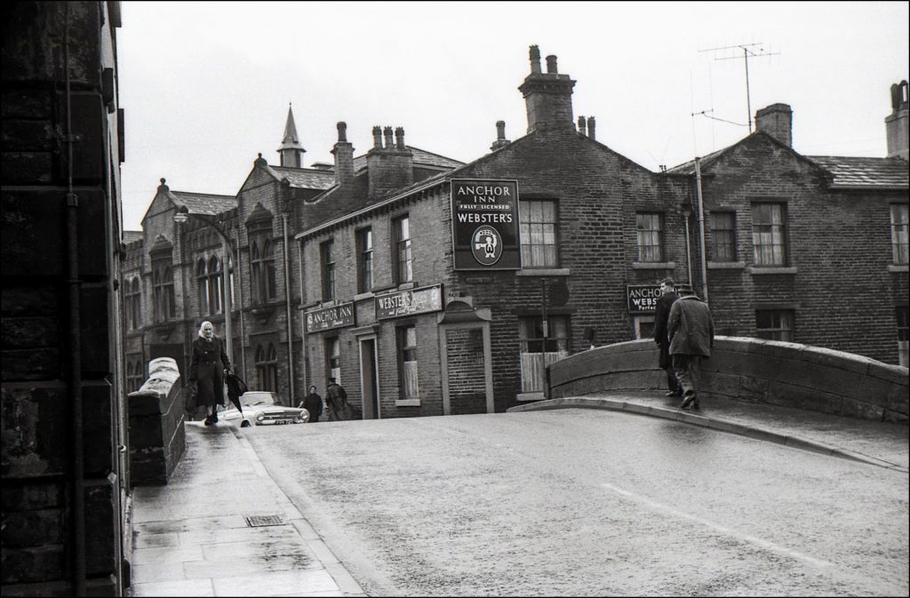
The Anchor Bridge is next along the route, so called because of the close proximity of the Anchor Inn public house on Briggate. This bridge formed part of the main road from Lancashire which travelled through Rastrick and crossed the Calder via the Rastrick bridge at Bridge End. Until the Huddersfield Road bridge was completed in 1824, Rastrick Bridge was the only way to cross the river unless using the ancient ford at Snake Hill off Birds Royd Lane. Being such a major road, a bridge had to be built as soon as the canal started to be constructed and so it dates from around 1764. The original Anchor Inn must have also dated from the same time as it was built to cater for the teams of navvies who dug out the cut with picks and shovels. As the canal building moved westwards, the new clientele were the watermen who ran their barges up and down the navigation.
The Anchor Inn was rebuilt in 1858 though the present cellars are from the original building. There were also modifications to it in 1906 when the Borough Club, better known as the Assembly Rooms were built, replacing Queen Anne Square which dated back to before the English Civil War period.
Heading out of Brighouse towards Ganny Lock, an old building previously known as the Brighouse Upper Mill can be seen on the opposite side to the towpath. Also known as Brooke’s Mill, it dates to before 1826 and was attacked by rioters during the Plug Riots of 1842 which came about because of an economic recession. In order to maintain profits, many mill owners reduced the wages of their employees which resulted in mass walk-outs, never previously seen in this country. The rioters emptied mill dams and pulled out the plugs of the steam engine boilers which rendered the machinery within the mill incapable of being used.
Samuel Brooke was a card manufacturer at the mill until he was declared bankrupt in 1861 and then in 1884, the building was used as the new roller mill belonging to Thomas Sugden & Sons Ltd. In 1869 there were local newspaper reports regarding the dangerous road between Sugden’s Upper Mill and the Anchor Inn. People were in danger of being run over on the Anchor Bridge as the horses drawing fully laden carts were made to run up the incline and then turn sharply onto the bridge where many pedestrians were walking. The horses couldn’t get enough momentum to pull such a weight if they simply walked therefore running was the only option. Several unsuspecting pedestrians were knocked down and injured on the bridge as a result.
In 1895, when the previously mentioned fire hit the Sugden’s mill on the Calder, flour production was temporarily taken to the Upper Mill until the new Brighouse Mills were opened in September 1896. When Sugden’s had the Upper Mill, sacks of flour were lowered through a wooden structure, fixed onto the side of the mill before being received onto the waiting barges below.
Amongst the other occupiers at Upper Mill were Binns & Berry, lathe manufacturers from Halifax who moved in when Sugden’s vacated the property in 1898. Binns & Berry are still in existence today in Halifax.
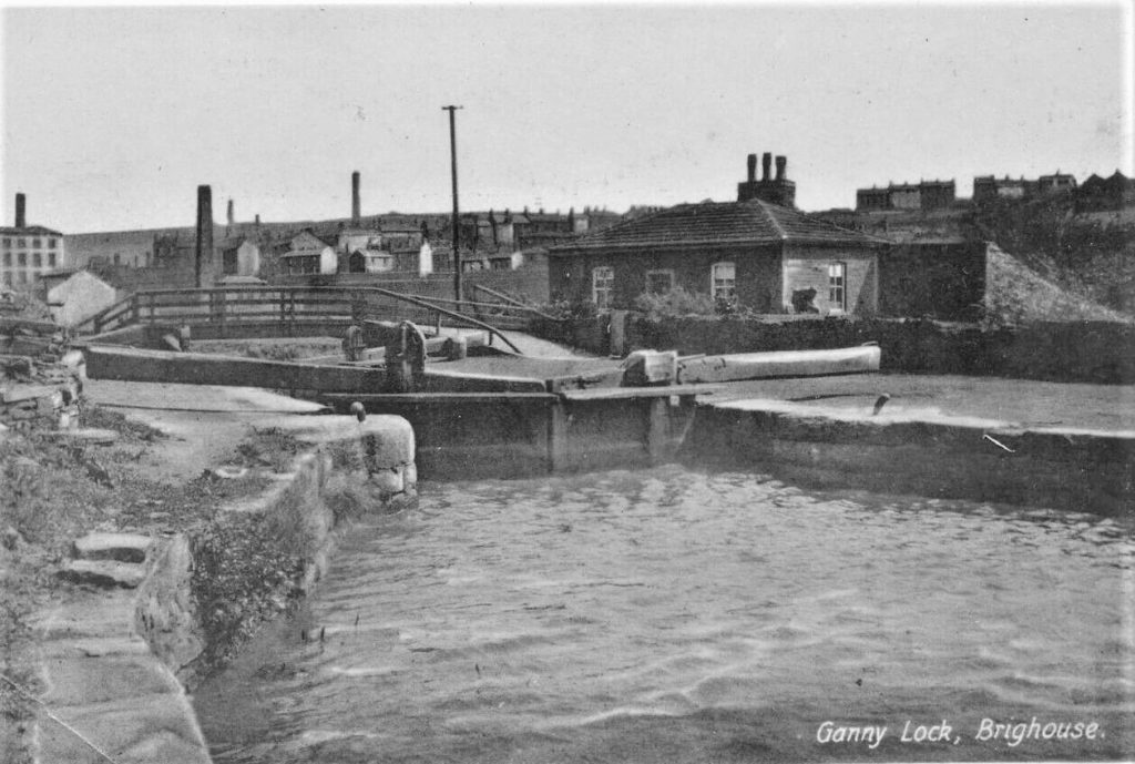
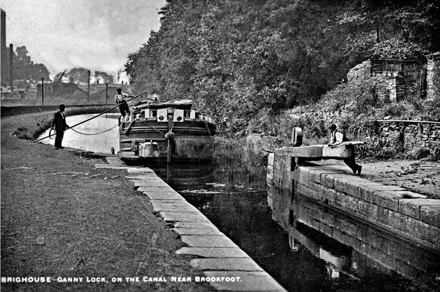
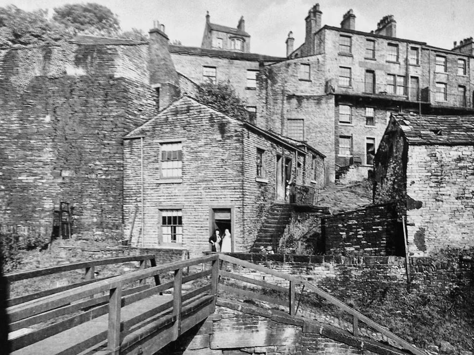
The above three photographs were all taken at Ganny Lock. The top one is looking at the lock facing towards Brighouse with the lock-keepers cottage on the right. Above the wooden footbridge, buildings at Lillands can be seen whilst to the left is the old Broad Holme Mill on Atlas Mill Road, which was burnt down in 1932.
The centre picture shows a barge entering the lock at Ganny from Brookfoot with the buildings on Brookfoot Wharf visible to the left of the trees.
The bottom picture shows the wooden footbridge and steps leading through the old houses at Vine Court and Vine Grove, up to Elland Road behind.
It was at Ganny where the navigation re-entered the river after the canal had by-passed Brighouse. The route then followed another short section of canal which travelled through the opposite fields, below Lillands. This canal then joined back up with the river on the west side of Brookfoot weir. Following a number of devastating floods on the low-lying fields, the current section of canal between Ganny and Brookfoot was built in 1780.
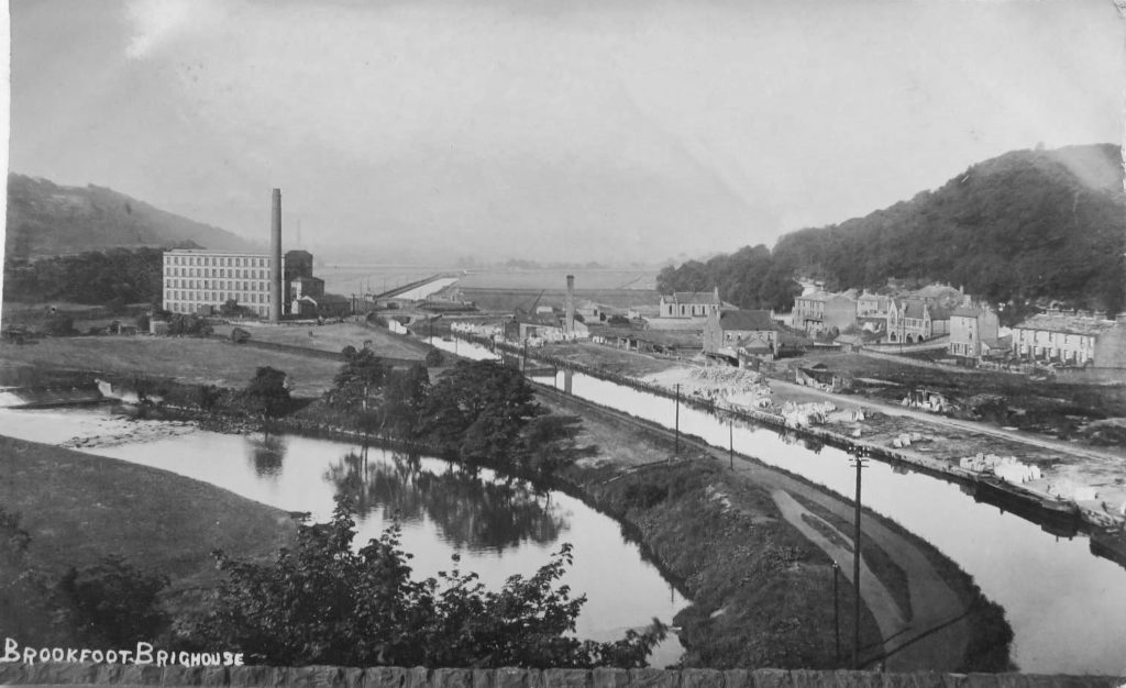
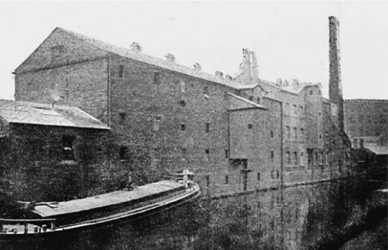
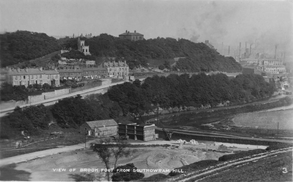
The above view is taken from high up on Elland Road, looking down onto the canal and river just before the ‘Brookfoot Bend’. To the left can be seen the weir on the river which was originally built to power an old watermill that had stood at that point since the early 1600’s. The 19th century five-storey Brookfoot Mill is beyond and to the right is the canal, heading off towards Elland just over 2 miles hence. In the foreground to the right is Brookfoot Wharf, originally built by the Freeman family of Southowram as a point where the stone from their quarries could be loaded onto barges and shipped to the coasts for distribution around the world.
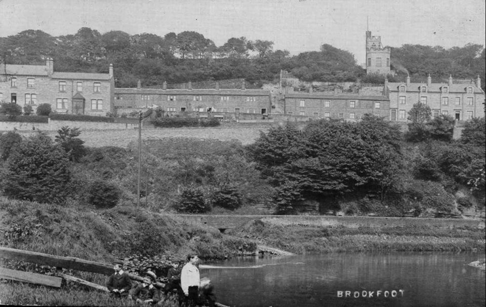
Now very much overgrown with trees, the fields beyond were used by local farmers for growing hay and for grazing sheep and cattle. The triangular field just below the mill chimney was used as the local cricket field and with its own school, church and three pubs, Brookfoot was a thriving community in its own right.
The next photograph is taken on the river just above the aforementioned weir with the houses on Elland Road and Brighouse Wood Row which leads onto Brighouse Wood Lane, perched on the hillside. The light coloured building above the houses is Vista Bellissimo, built in 1897 to celebrate Queen Victoria’s Diamond Jubilee.
Another view of the houses mentioned above but this time the photograph was taken below the weir. On the left bank, just before the bend in the river, the overflow from the canal can be seen entering the Calder. The canal towpath is just behind the low wall. This same location is still accessible and amazingly, a sand and pebble beach was left here when the flood waters subsided after the Boxing Day floods of 2015.
A different angle now, this time taken from Brookfoot Lane and showing the houses on Elland Road with Vista Bellissimo above them on the left side of the photo. Going down to the canal, there are three coal staithes on the photograph just to the right of the stone building near the bend in the canal and river. A horse and a couple of carts are visible in front of the staithes whilst a crane is just to the right, positioned on the edge of the canal wharf. So what is going on?
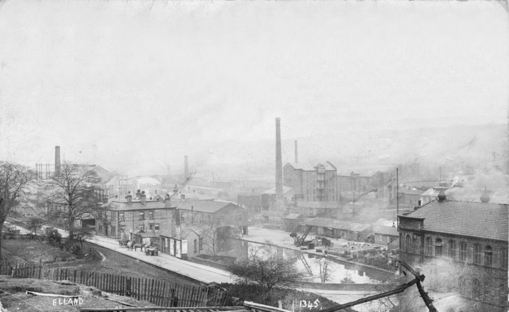
A large mill known to many as the B.D.A. or Bradford Dyers Association was located on the opposite side of Elland Road on the Brookfoot Bend. It had one of the largest coal fired electricity generators in the country which burnt around 100 tons of coal per day. To reduce transport costs, the company bought their own barges and they were used to bring coal from the East Yorkshire coalfields around Selby. The coal was taken off the barges via the crane and a large grab then deposited it into the three staithes. The horses and carts were then positioned beneath a staith and the coal was dropped via a shute into the carts before being taken up the roadway and across to the mill. Can you imagine the smoke it created but that would be nothing compared to what the mill chimneys in Brighouse, on the top right of the picture, are churning out. How many mill chimneys were there in Brighouse at the peak I wonder?
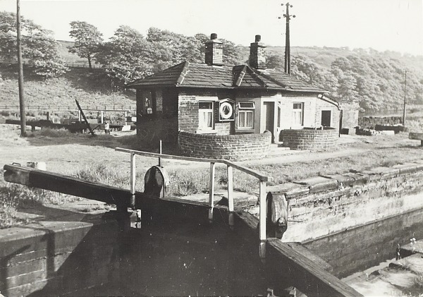
After travelling past the Brookfoot Wharf on the opposite side of the canal, the towpath arrives at Brookfoot Mill and Brookfoot Lock. The section of canal from Ganny Lock, built in 1780, re-entered the river at this point and then continued on its upstream journey towards Elland. It wasn’t until 1805 that work began on the current navigation between Brookfoot and Elland, which took three years to complete.
The above photograph taken in 1955 shows the lock-keepers cottage with the lock gates in front. The lock gates leading into the river can be seen to the left of the house. Gates such as these that separated the river from a canal were known as flood lock gates and had to remain closed when the river levels were high to avoid flooding and debris being swept into the canal. Beyond the river in the background is the hillside leading up the fields to the railway tracks below Lillands Lane. Stone was brought down from the Lillands and Longroyd quarries at Rastrick to a small river wharf that was located on the opposite bank of the river at this point.
This photograph above was taken by my grandfather, Fred Eccles in 1922. It is taken from the bridge at Brookfoot Lock looking back towards Brookfoot Mill and the houses (once again!) on Elland Road. The bridge that can be seen on the photo is known as Camm’s Bridge after the 19th century textile manufacturers who occupied the mill at that time. At the time of the photo, it was owned by the toffee manufacturers Turner & Wainwright. They sent tins of Turnwright’s toffee out to the Brighouse soldiers who were fighting at the front in the 1st World War. It is probably best know for producing Kossett Carpets in the 1960’s.
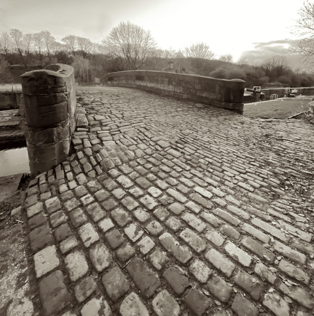
The towpath travels over Camms Bridge onto the opposite side of the canal for a short distance before returning back to the other side via the cobbled Brookfoot Lock bridge. Note the grooves in the stonework at the end of the bridge, worn out by many years of tow ropes rubbing against them.
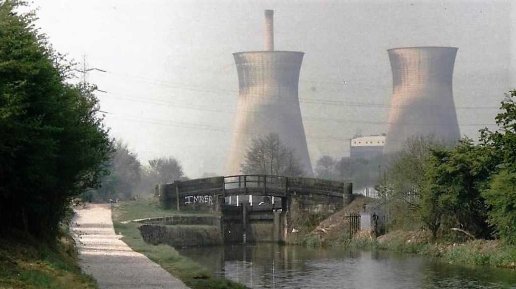
Continuing along the towpath from Brookfoot towards Cromwell Bottom Lock, the view is somewhat different nowadays to when this photograph was taken by Patricia Keene and her husband, Malcolm, around 55 years ago. The bridge and lock still survive but the cooling towers at Elland Power Station disappeared in a dramatic controlled explosion in 1996.
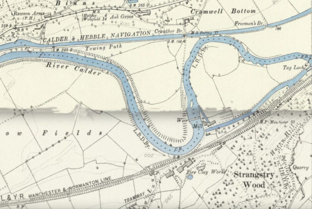
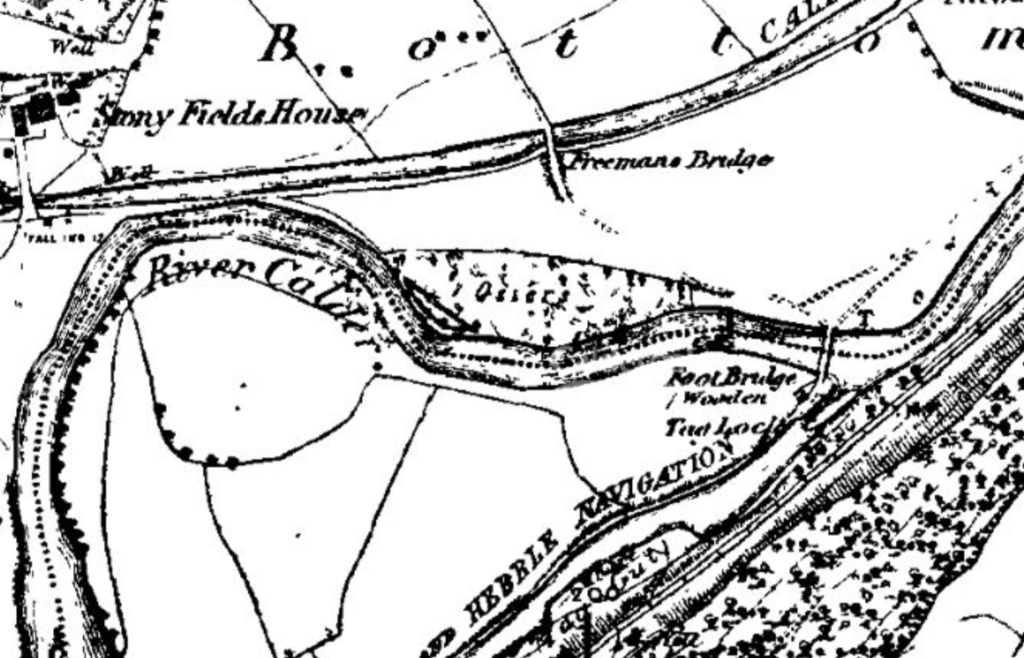
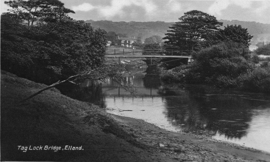
For the above map, I have had to ‘stitch’ two different ones together as the area shown is on separate maps, hence the difference in shading. A brief description of the area shows part of Elland Road with the former Rawson’s Arms near the top left corner. Towards the top centre, below the letter ‘C’ in Cromwell Bottom are two buildings which are Cromwell House Farm. A path leads from the farm over the canal via Crowther Bridge. Nowadays, this path leads to the Nature Reserve café and to the two metal bridges that cross over the river. However, on this map there isn’t a bridge at that location. I will come to that shortly. Below the loop in the river is the Lancashire & Yorkshire Railway described as the Manchester & Normanton Line with the Fire Clay Works and Strangstry Wood to the bottom of the picture. This leads up to Lower Edge and the Boothroyd estate which is just off the map. On the extreme right, where the river and Tag Cut meet at Tag Lock, you can see a line across the river with the letters F.B. This was a footbridge that led from the towpath coming up from Brighouse onto another towpath that ran along the north side of Tag Cut.
At this time, around thirty quarry workers who lived in Rastrick, worked in the Southowram quarries. To get to work, the men had to use the delvers tracks through the woods, some of which were used to take the stone from the Rastrick quarries at Lower Edge and Boothroyd, down to a wharf on Tag Cut. The foot crossing across the railway lines still exists because it has been a public footpath for so many years and was in existence long before the railway bisected it in 1840. The path then crossed the canal via the packhorse bridge at Tag Cut Mill, denoted by the word ‘Mill’ on the map. Because there was no other way of crossing the river other than by stepping stones, the workers had to walk along the full length of the Tag Cut towpath to where they crossed the river via the footbridge on the right of the map. From there, the men had to follow the river back towards Crowther Bridge where they crossed the canal and went up to the Southowram quarries via the path through the farm.
For many years, the path through Cromwell House Farm had been the subject of a dispute as to whether it was a public right of way or not but in 1899, the farmer, John Murgatroyd, decided to lock the gates so that the men couldn’t wander across his land. When the men broke the lock on several occasions, four of them were summoned to appear before the Magistrates on a charge of wilful damage. The land agent for the farms owners, Saville Estates, was Mr. Lipscome JP who argued that despite there being a sign showing the route as a footpath and Ordinance Maps also showing the same, it was not a public right of way in his opinion. After evidence that the villagers from Southowram had for many years also walked the route together with a marching band, in order to maintain their rights to use it, the case against the Rastrick delvers was dismissed.
Having to go via Tag Cut and then double back upon themselves was a long detour at the best of times. Crowther Bridge was more or less in a straight line as the crow flies to the railway crossing therefore, if a bridge could be built at that location it would be of great benefit. In 1905, after several more years of wrangling, Saville Estates finally agreed to donate a small piece of land where a footbridge could be erected over the river, just to the south of Crowther Bridge. Although not shown on the 1907 OS Map, it was built around that time and a bridge is still in existence at that location to this day and used by the many visitors to the excellent Cromwell Bottom Nature Reserve.
Cromwell House Farm can be seen in the distance in the above photograph which was taken from the aforementioned footbridge over the river. Whilst difficult to make out, the section of track upon which the cows are standing is slightly raised and is the start of the Crowther Bridge crossing which passes over the canal at this point. The canal is hidden behind the dry-stone wall to the rear of the grazing animals in the fields. Once the footbridge had been built and the right of way through the farm had been sorted, the route to the Southowram stone quarries for the Rastrick quarrymen was so much easier.
On the 1854 map above, the area to the north of the wooden footbridge at the eastern end of Tag Cut was fertile farming land. Before the arrival of the canal, this area was overgrown with weeds that were growing in the acidic soil. Barges came up the navigation from the eastern port of Goole to collect the fine quality stone from our local quarries but were very often empty on this leg of the journey. It was decided to fill the empty barges with lime which was then spread onto the weed covered soil. This neutralised the acidity and killed the weeds and by increasing the Ph level in the soil, farmers were able to sow grasses which were ideal for grazing sheep and cattle. The naturally produced manure then helped to maintain the neutral alkaline levels. The fields were eventually abandoned as agricultural land though some old stone gate posts can still be found in this area, giving a clue as to its former use. Because of regular flooding, part of the low lying area has now been taken over by a large lagoon on the Nature Reserve.
The section of land to the south of Freeman’s Bridge, close to the river and near where the lagoon is now located, were the Osier beds. This is shown by the word ‘Osiers’ in the centre of the map.
An osier is the ‘salix viminalis’ or Common Osier Willow to give it the correct title. The twigs were cultivated in marshy areas along the banks of the Calder. They were harvested between October and February and used in what is commonly known as the wicker basket making trade. The baskets varied from small household baskets to large skips that were used in the textile mills for storage of bobbins, shuttles and spun yarn. I remember them very well from when I worked at Joseph Lumb’s worsted spinners in Huddersfield after leaving school and there were literally hundreds of them in the mill. Basket weaving was a huge trade in Brighouse in the 1800’s, made from the Cromwell Bottom osiers. One small twig placed in the marshy ground would produce six to eight branches of around eight feet in length during the first year. Some were used fresh and green whilst others were woven with the bark still attached. Others were stripped and sun-bleached and others were boiled to enhance their colour. Stored twigs were soaked before use to make them pliable and easier to handle during the basket weaving process. The word ‘wicker’ comes from a similar Saxon word meaning supple.
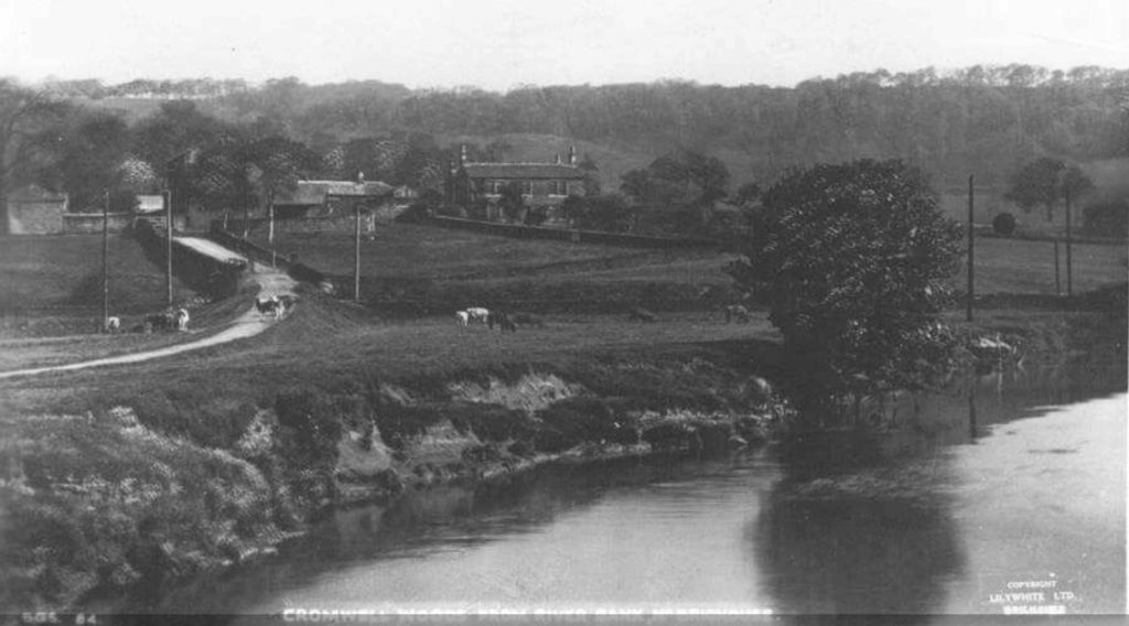
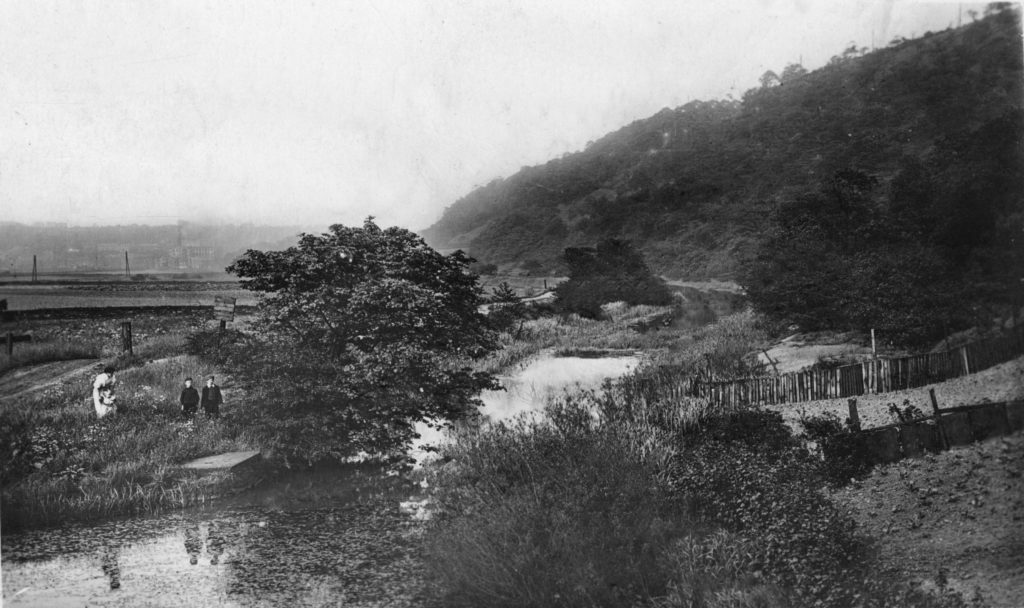
It is still possible to stand at the location of the above photograph which is at the eastern end of Tag Cut where the footbridge used to traverse the river. The bridge was to the left whilst the lock-keepers cottage was to the right. On the extreme right is the high wall which carries the railway between Brighouse and Halifax above. Immediately beyond the river in the distance is Brookfoot Mill with the small hamlet to the left. On the extreme left of the picture are the houses at Grove Cottages and Grove Terrace off Elland Road. The towpath can be seen on the left bank of the river which was used by the hauling horses to tow the barges along the river. The horses had to cross the river at this point to continue their journey along Tag Cut. After the canal between Brookfoot and Elland was opened in 1808, this route became less important and was mainly used for the transportation of Rastrick stone from Tag Cut wharf. It was also used for pleasure boats and by local anglers as the commercial traffic decreased.
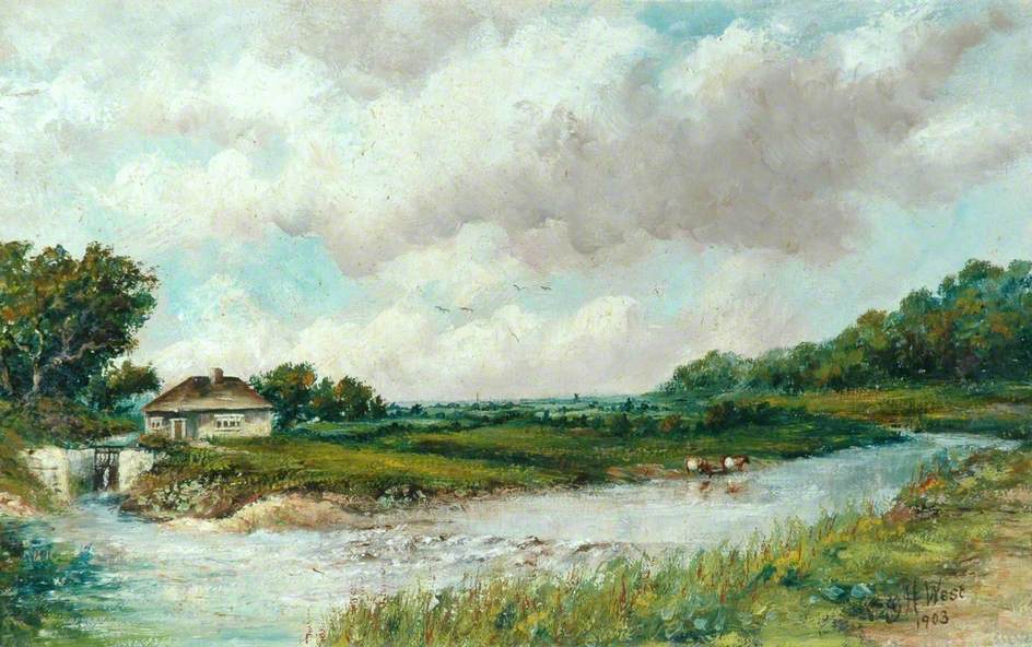
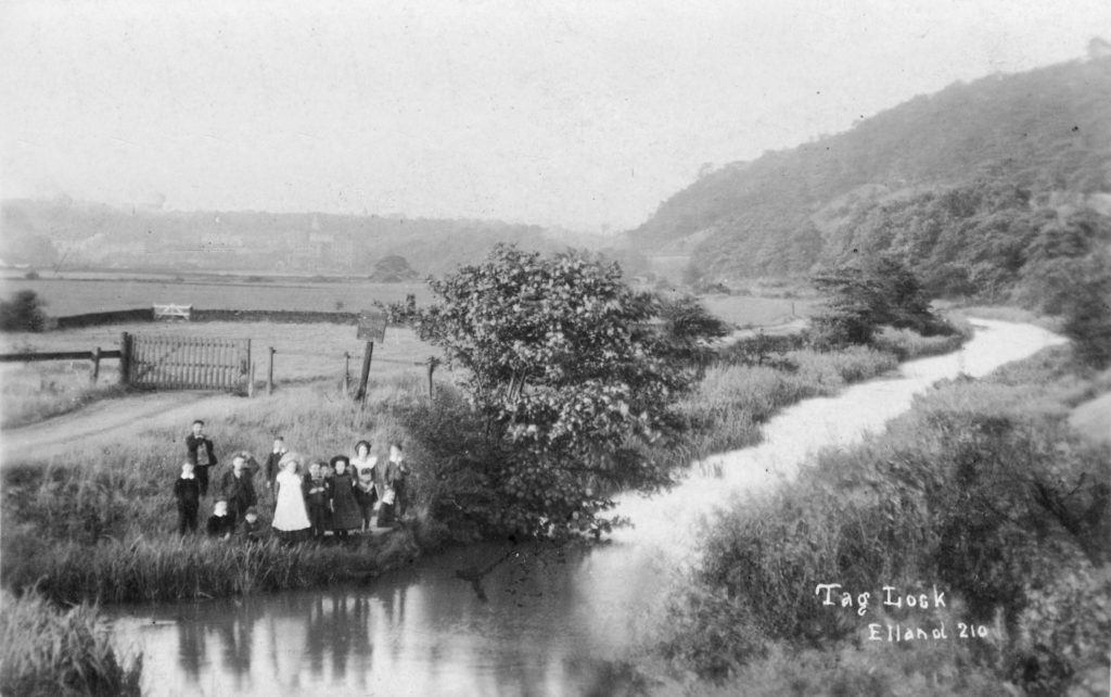
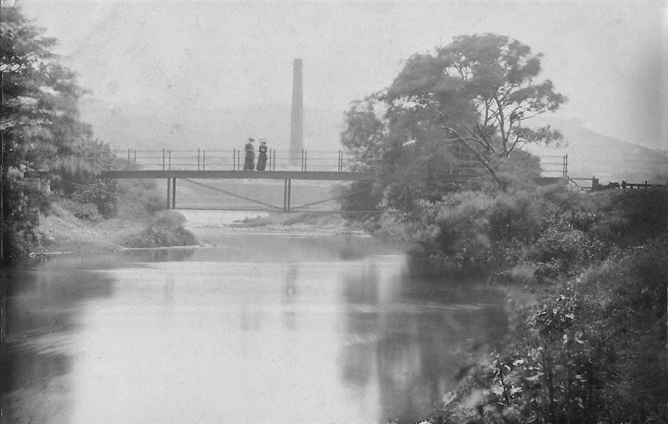
The above painting from 1903 is by the artist George H. West and is owned by Calderdale Council and probably stored away in some vault beneath the Halifax Library. The scene shows the River Calder flowing down from Elland past the entrance to Tag Lock and the Tag Cut canal. The lock gates and lock-keepers cottage make up the scene to the left hand side. The river goes around a large ‘U’ bend and Tag Cut had to be built for two reasons. The first reason was the shallow rocky river bed at this point. The artist has shown the rough water as it travelled over the rocks but at the time when the canal was built, dynamite hadn’t been invented and it would have proved very difficult to dam the river and then blast the submerged rocks with black powder. The second reason was the weir across the full width of the river a little further upstream.
The artist has positioned his easel on the towpath leading up from Brighouse at a point where the hauling horses had to cross the river to continue towards Elland so at this point there was a wooden footbridge spanning the Calder. The painter has used his artistic licence and omitted the bridge making the area look a lot more scenic than it actually was.
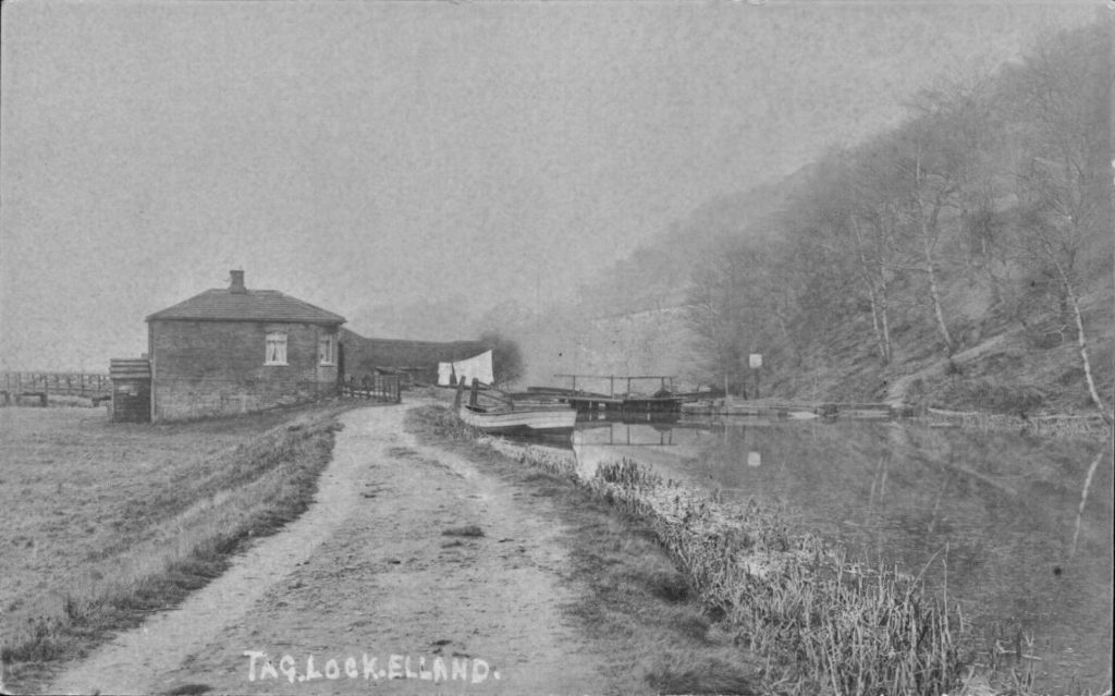
Above is a view of the Tag Cut canal with the lock gates at the eastern end, beside the lock-keepers cottage. How different this scene is today. The cottage has been replaced by an electricity pylon, the grass area to the left has been taken over by trees and the canal is silted up and full of fallen leaves and dead tree branches, an ideal habitat for the damsel-fly. The railway embankment can just about be made out above the gates. What is fascinating about this photograph is the old wooden footbridge over the river, which is visible to the left of the cottage. I have not seen any other photographs of this particular bridge which disappeared in floods over 70 years ago and was never replaced. Very few barges used this stretch of canal at the time and the towing horse was made almost obsolete with the advent of steam and diesel engines.
It is interesting to see that the lock-keeper has his own boat which he would no doubt use for trips to the shops at Brookfoot, Elland or Brighouse. He would obtain heavy things such as coal from the passing barge owners, often trading things such potatoes, salads and vegetables which he grew in an allotment area by the canal.
A path is visible coming down from the woods on the right and immediately at the bottom of the path you can make out the facing blocks of the overflow channel to the right of the lock gates. The overflow is usually covered in dead leaves but after heavy rain, it still comes into use and when the debris is washed away, a wonderful cobbled slipway is revealed which looks as good as the day it was built around 1766-67.
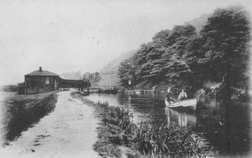
Taken from almost an identical position as the previous photograph, this appears to show the same boat that was moored outside the lock-keepers cottage being punted along Tag Cut in the direction of Elland.
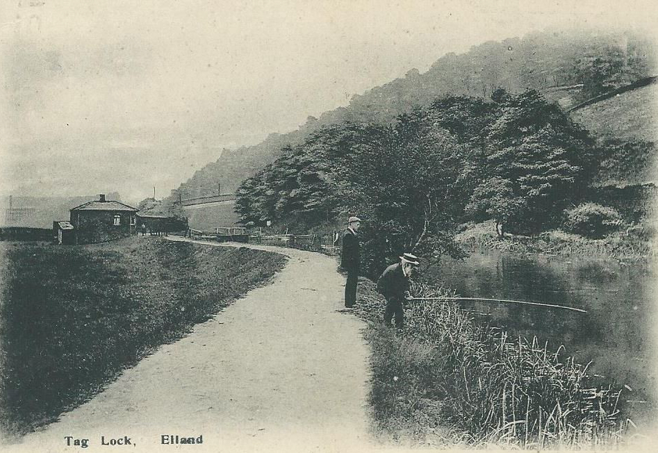
Anglers enjoyed their sport along the banks of Tag Cut for many years and it was a renowned area for fishing. The Halifax Amiable Brothers Angling Society obtained the fishing rights there around the year 1890. In 1898, the Brighouse News reported that the club had fifty-one members and they had stocked the cut with a large number of good sized fish. The previous year, the club acquired a silver cup to the value of 12 guineas which was named the Diamond Jubilee Cup in honour of Queen Victoria’s 60 years reign. It was decided that the first person to win the trophy three times would become the absolute owner. This was done rather quickly as Mr. Helliwell Stake won it three times during the first five years. Some readers may remember Mr. Stake who opened the famous Bow Window sausage, peas and muff shop on Briggate, Brighouse in the 1890’s. His son, Edmund took over from his father when he retired and ran the shop until the early 1960’s when it closed and was demolished.
In the Leeds Mercury dated the 19th September 1903 under an article entitled Angling Notes, it was reported that, ‘on Friday week, Mr. H. Aspinall, a member of the Halifax Amicable Brothers Angling Association caught a trout weighing 7lb 3oz at Tag Lock. Mr Aspinall was fishing for roach with wasp grub and using fine tackle. The struggle lasted half an hour. This splendid specimen has been handed over to Mr. Naylor, taxidermist, Brighouse, for preservation. Tag Lock is situated between Brighouse and Elland and is reputed to hold some good fish. Mr. Aspinall has received many letters of congratulations from anglers throughout the country.’
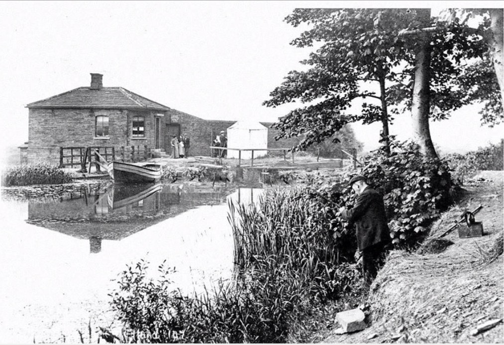
This next photograph is taken from the Rastrick bank of Tag Cut and would be near to where the original wharf once stood for around 100 years from the 1770’s. Here, the barges would have been loaded with stone from the Lower Edge quarries, having been brought down to the wharf on lumbering wooden carts. At this point, the canal was made much wider than the remainder of Tag Cut so that barges could moor at the wharf and not obstruct the passage of other waterway traffic. Once laden, the barge would exit the canal into the River Calder via the lock gates beside the lock-keepers cottage. This was the start of the 48 mile journey via the Calder & Hebble Navigation to Wakefield and then onto the Aire & Calder Navigation to Goole via the River Ouse, negotiating thirty-one locks in the process.
There is an article consisting of just three pages which explains how the horse drawn barges were operated on this link:-http://www.canaljunction.com/craft/horsedrawn.htm
The next two photographs above are taken from roughly the same location. This is at the end of the western end of Tag Cut, near to where the canal rejoined the River Calder before heading up towards Elland. By the time of these Edwardian photographs, Tag Cut was hardly being used for commercial traffic. Stone was not as popular in the building trade, concrete flagstones were replacing the Elland flags for paving, cheaper slate was preferred in new builds to stone roof slates and so the stone quarries started to close down. The railways had taken much of the canal trade and with a great improvement to roads, the abolition of tolls on the turnpikes and motor lorries becoming the modern commercial transport method, Tag Cut was left to nature.
The mill at Tag Cut was demolished at the turn of the 1900’s and the canal began to become overgrown with aquatic plants and weeds. It became a fashionable nature walking area for families and courting couples and in 1895, the Huddersfield Chronicle reported that the Lindley Mechanics Institute Naturalist Society went on a ramble around Tag Lock and Park Wood, gathering species of plants which were of ‘good quality and quantity. The red campion and yellow toad flax were in splendid bloom and the wood was strongly presumed with sweet cicely, although it had been out of flower for some time. Four very rare specimens were found, purple media, naked-flowered crocus, meadow clary and amphibious bistort. The enjoyable and instructive ramble was brought to a close too soon by the approaching dusk of the evening.’
In 1947, the Calder & Hebble Navigation Company announced that it had officially abandoned the canal. Sand and gravel pits were excavated at nearby Cromwell Bottom and then the whole area became a tipping ground for household waste and fly ash from the Elland Power Station located on the opposite side of the river near Tag Cut. It is amazing how the fortunes have changed as the former power station dumping ground has once again returned to become a beauty spot thanks to the efforts of the volunteers at the Cromwell Bottom Nature Reserve. They have transformed the paths through the meadows and wetlands which are now a wonderful habitat for a variety of insects including damselflies, butterflies, dragonflies and moths and not forgetting the popular bird feeding station.
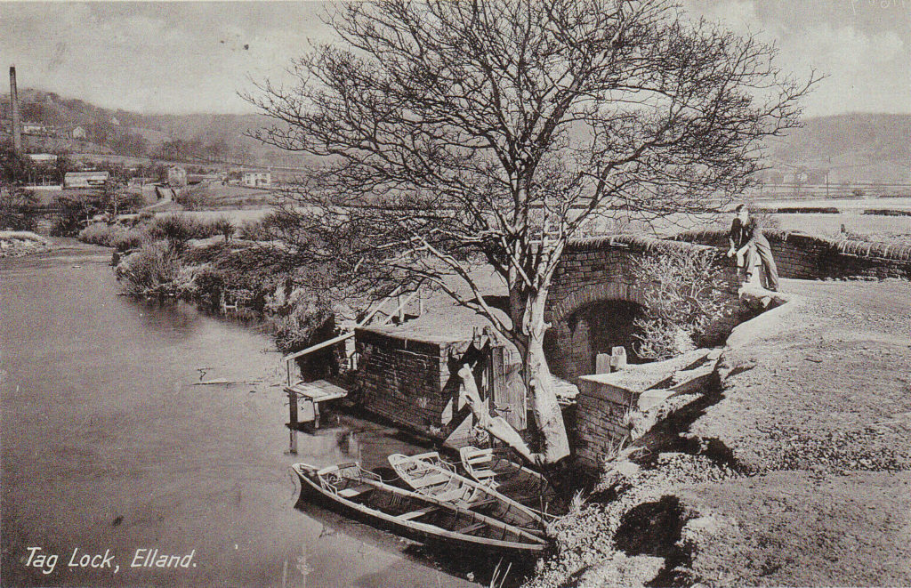
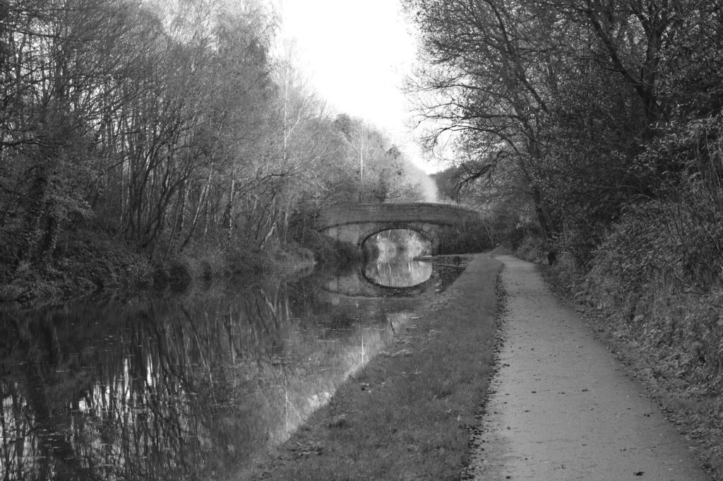
At the western end of Tag Cut, where the canal rejoins the river, there is the most beautiful packhorse bridge that dates back to when the canal was built almost 250 years ago. The arch is still in place and it is possible to walk over it but the walls to either side have now gone. The photograph shows Fred Craddock’s rowing boats. I know some Rastrick gentlemen of a certain age who can still remember the boats, or subs as they were jokingly called due to the fact that they all leaked water. When hiring them, you were issued with two ores and a ladle ! It wasn’t advisable to go too far downstream because the weir was only a few yards away. This was the only bridge over Tag Cut from the Rastrick side of the canal though it was possible to cross at the opposite end via the walkway on the lock gates.
Sadly, the canal side of the bridge is now filled in for over 100 metres but Tag Cut still has several sources of water which flow into the cut from the Rastrick hillside. One of the water sources is bright orange as the water comes up from a flooded underground mine and the water is tainted from the iron oxide contained in the shale deposits which are below the valuable fine quality sandstone. The shale was also quarried near to this location resulting in the creation of the former Fire Clay Works and then latterly the Elland brickworks. As the valley between Rastrick and Southowram was carved out during the ice-age, the geology is replicated on both hillsides hence Knowles pipeworks on Elland Road has utilised the shale and clay deposits for many years.
Whilst carrying out this research, I have come across over twenty reports of both adults and children who lost their lives in the river and canal around Tag Cut between 1860 and 1920. Most of the circumstances were quite horrific and whilst the area is full of interesting history and is enjoyed by many people today, as they walk around the Nature Reserve, it was also an area of extreme sadness to many, all those years ago
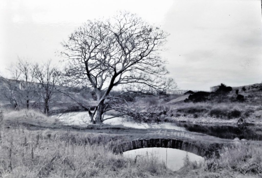
Another of Pat and Malcolm Keene’s photos from the 1960’s is taken at Tag Cut’s packhorse bridge, with the river beyond leading up to Elland. Craddock’s boats were moored on the opposite side of the bridge. The path leading off to the left follows the river around the meander and goes beneath the railway via a bridge. The track then continues across the fields towards Old Earth, Elland. Another path, where the photographer would have been standing when this snap was taken, also goes off to the left and up to the railway foot crossing. It then ascends through Strangstry Wood to the quarries at Lower Edge. By taking a right turn at this point, the path leads down to the previously mentioned bridge across the river from the year 1907. It then arrives at Crowther Bridge which spans the 1805-08 section of the Calder & Hebble Navigation.
This photograph above shows the footbridge over the River Calder between the western end of Tag Lock and Crowther Bridge. It is facing towards Cromwell House Farm with the Southowram hillside in the background. The path from Tag Cut is on the opposite side of the river at this location and in order to get back to Crowther Bridge, walkers would have to cross the bridge from right to left.
Having crossed the river on the way back to the main section of canal at Crowther Bridge, the camera operator has turned around and taken this photograph of two ladies standing on the metal footbridge. The previous photograph was taken from the sloping right banking of the river, just beyond the bridge. The Fire Clay Company chimney is in the background with the ridge of the hillside at Lower Edge just visible through the haze. It was this bridge which made life so much easier for the Rastrick quarrymen who would cross in either direction, each day, whilst on their way to and from work at the Southowram stone quarries. The weir near to the western end of Tag Cut can be seen under one of the bridge’s crossbeams.
Although these next photographs are relatively modern, they now form part of the history of the canal at this location. The Boxing Day Floods of 2015 devastated the area causing several million pounds worth of damage to bridges, walls, flooded properties and vehicles. The old Crowther Bridge had stood there since 1808 but such was the strength of the current flowing down the canal after the river had burst it banks that the structure was unable to cope with it.
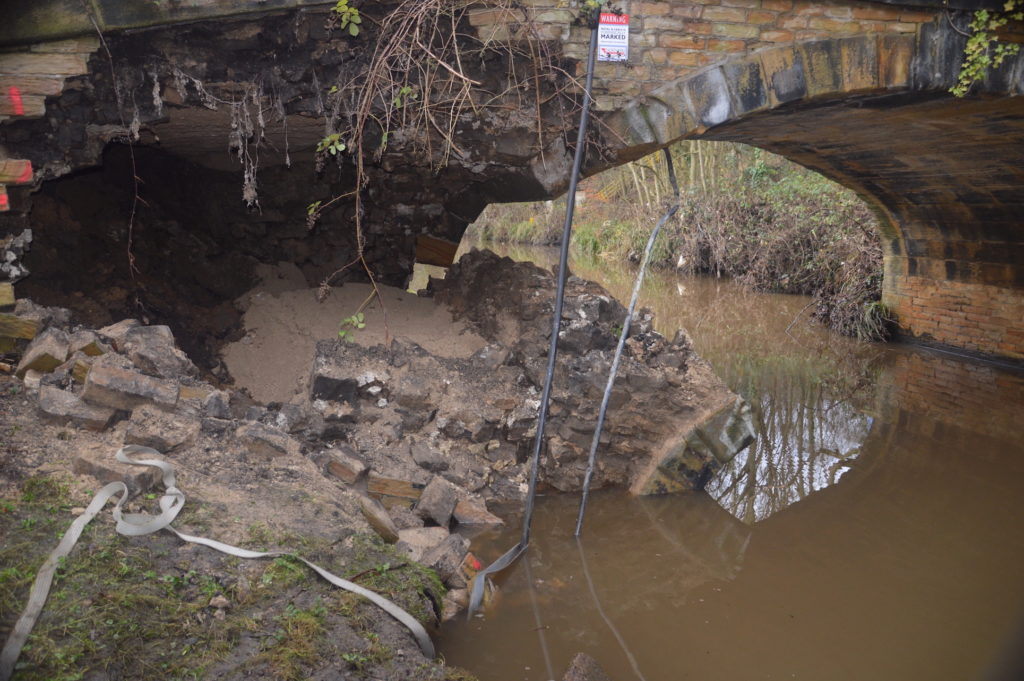
The foundations were compromised to such an extent that the archway collapsed onto the towpath. The bridge was so unstable that it could not be saved and had to be completely taken down. The above photograph shows the old bridge from the Brookfoot side of the bridge.
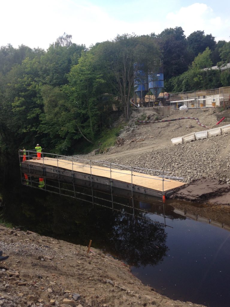
After the bridge had been demolished, new foundations were necessary before the arduous task of erecting a new bridge in a similar style to the previous one but with a much cheaper concrete under-arch as opposed to one of stone.
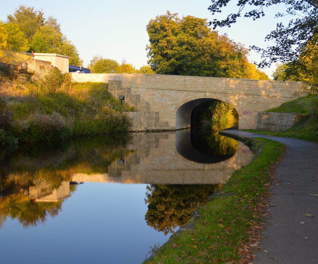
Upon completion of the new canal crossing, it took less than a week for the stonework to be defaced with spray paint by some idiot who had no comprehension of the effort and cost that went into replacing Crowther Bridge.
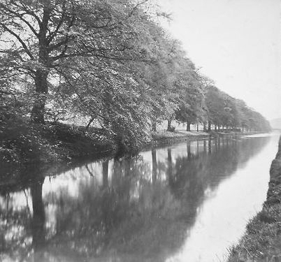
The 1921 photograph to the left shows the Calder & Hebble between Crowther Bridge and Park Nook and is looking back in the direction of Brighouse. The photographer would have been standing on the towpath. The area on the opposite side is known as Ash Grove as the house of that name is situated on the nearby Elland Road. New holiday chalets have been built close to the location of the photograph and additional apartments have been created at Ash Grove House.
Further towards Park Nook, the canal widens to accommodate moored barges at an old wharf area. They transported coal from the Binns Bottom Colliery, a mine located between the canal and Elland Road which was in use between 1854 and 1877.
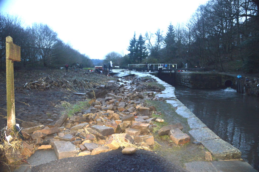
The next stop along the route to Elland is Park Nook Lock. Again, it was an area devastated by the floods in 2015. I had returned home from Spain for the Christmas holidays, leaving lovely sunny weather behind and it was a shock to see not only the horrendous destruction but what the power of water can do. Here, a drystone wall was completely washed away by the force of the water….. on a canal ! To the left of the two people standing by the lock gates is a Calderdale Council wheelie-bin and a hot-tub, both washed away from someones garden. A Kirklees Council van was swept away from the Colliers Arms car park and it sailed over the lock gates at Park Nook before sinking a further 100 metres downstream. I witnessed its recovery as it had to be dragged up the steep hillside to Elland Road, through the trees and bushes. It was quite a job.

There cannot have been much time between the above two photographs being taken as even the trees have a similar shape. They show the former lock-keepers cottage at Park Nook, facing towards Elland. The top photo was kindly donated by Dave Lister and it shows the farming land between the canal and the river, an area now densely populated with oak trees.
This photograph is taken just beyond Park Nook. The Elland Lock and lock-keepers cottage further up the canal towards Elland. The two large mills on Park Road still survive but are no longer manufacturing premises but have been converted into residential apartments. The outside toilet blocks beside the canal in the foreground have long been demolished and the houses now have gardens that stretch right up to the waters edge.
This view of the bridge that carries the Brighouse to Halifax railway over the canal, prior to Elland Wharf has changed considerably since the photograph was taken. Immediately through the bridge is now positioned another much larger concrete structure with huge legs that support the A629 dual carriageway above. This major arterial road carries a large volume of traffic between Junction 24 of the M62 motorway at Ainley Top and the town of Halifax.
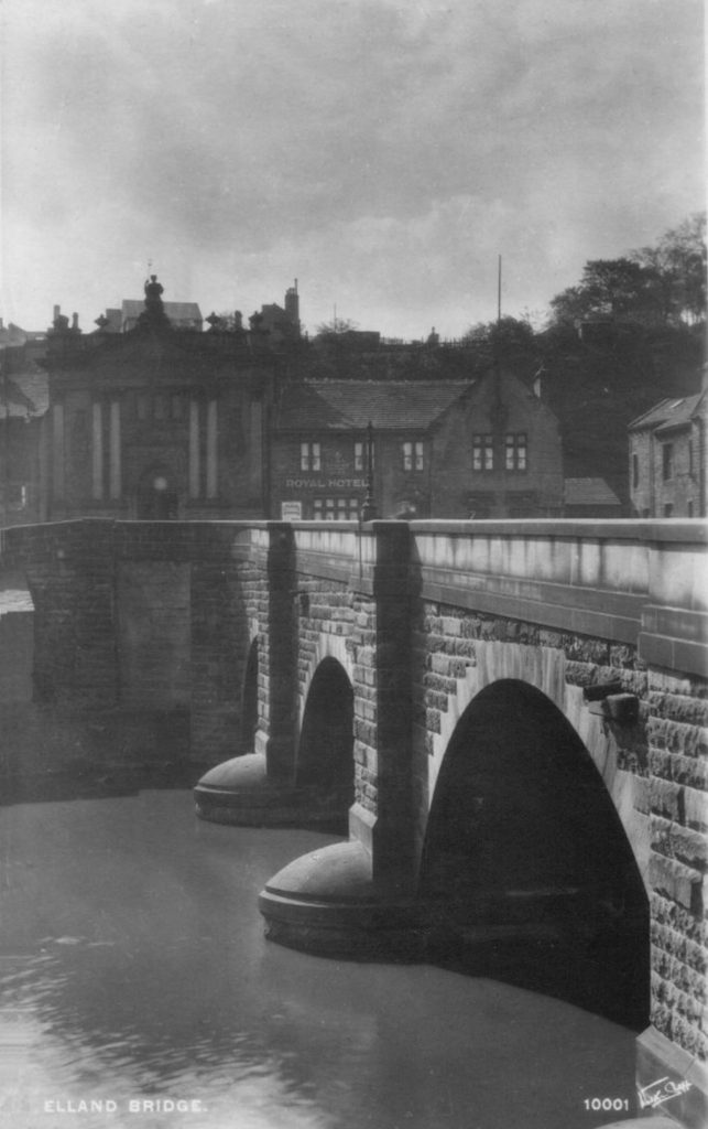
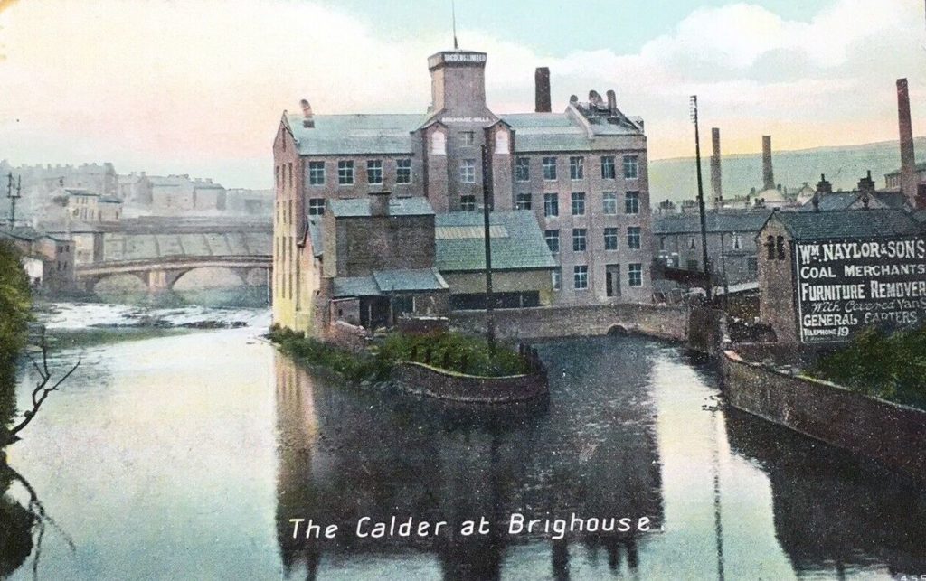
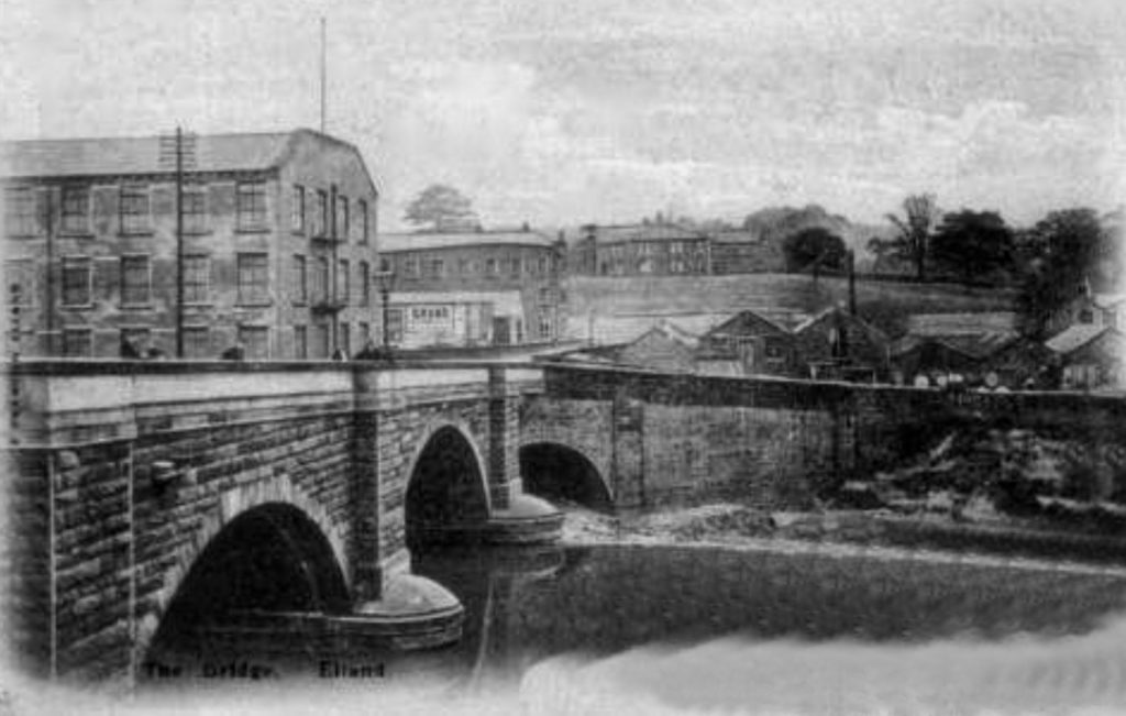
And so we come to the end of the journey from Brighouse to Elland along the Calder & Hebble Navigation with the odd detour. The above photo shows the Elland Bridge which spans both the river and the canal. On the Elland bank of the river is what used too be called The Royal Hotel. To its left is Britannia Buildings at Briggate, built in 1893 for the Halifax and Huddersfield Banking Company. It has been a Grade 2 listed building since 1968 and is easily identified by the four polished Aberdeen granite columns at the ornate frontage.
This is a view of the wharf, laden with goods ready for loading onto the barges with a single crane. Horses and carts are parked up on Park Road near to the Barge & Barrel public house with Elland Bridge curving around in the bottom right corner. The two storey building behind the pub and built on the canal wharf is described as the Canal Warehouse and Integral House which dates back from 1820. It is now deemed of national importance and is also a Grade 2 listed building.
This photo was taken from the Elland side of the bridge, looking across to the Exley bank of the river with J.H. Cockcroft’s mill on the left. Elland Old Hall can be seen elevated above the road, an ancient Manor House that was demolished in what many still call an act of vandalism by Calderdale Council in order to make way for the Elland By-pass, also known as the previously mentioned A629, Calderdale Way.
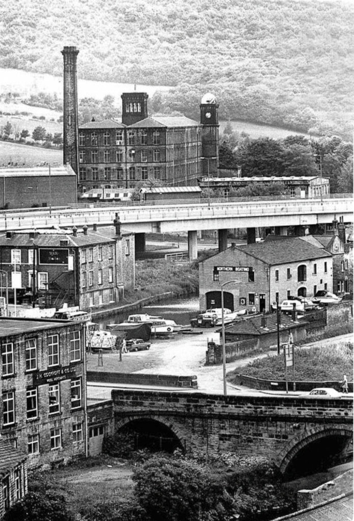
This final picture shows Cockcroft’s mill on the left and the entrance to Gasworks Lane opposite. The lane leads down to the wharf and other industrial premises beyond. There is now a path from here onto the canal towpath. One piece of useless information is that from Bank Street car park in Brighouse to the top of Gasworks Lane via the canal towpath and then back again is exactly 10kms (6.25 miles), a run that I used to time myself on but alas, no more !
Another Grade 2 listed building is the small single storey building with the three chimneys, adjacent to the wall. That used to be Elland Wharf office and also dates back to about 1820. To round off the quartet of historical buildings, the actual bridge at Elland is also listed.
Behind the raised roadway of the Calderdale Way is the wonderful old Valley Mill on Park Road which has changed its use from an industrial textile mill to modern residential apartments.
The Elland Bridge area was another place that was badly damaged by the 2015 floods when the road buckled and one of the arches partially collapsed on the canal bridge. The road was closed for a full year whilst repairs were carried out, which caused major traffic issues in the area as the town of Elland was inaccessible from the Elland Road/Park Road from Brighouse. The repair bill for this bridge alone came to almost five million pounds.
That concludes the historical old photograph history walk, I hope you have enjoyed it.
For more information about the history of the canal in Brighouse and the Tag Cut area, click on this link:-