I have catalogued all 8,453 burials in St. Matthew’s churchyard between the years 1798 and 2019.
In addition, I have so far photographed 424 gravestones and transcribed many of the inscriptions from them. These are also searchable in alphabetical order below the burial records. Please allow time for the records to fully load before searching.
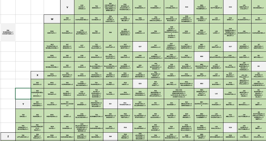
The bottom section of this page has a map of the New Yard section of the graveyard at St. Matthews which is free to download. It contains surnames in the various plot numbers that visitors can physically search.
If you have any questions, please see the contact page regarding how to get in touch.
THIS IS AN ONGOING PROJECT AND MAY CHANGE FROM TIME TO TIME
Click on the link below if you would like to download a copy of the map containing the graves whose indicator starts with a letter eg. F23
The graves were placed in a cross-section of letters and numbers and on the map, I have included the surnames of all the people interred in these graves in the appropriate blocks.
Of course, not all the graves have headstones therefore if you are doing a physical search, you may only see a patch of grass between other headstones but by looking at other named graves, you should be able to plot exactly where your deceased ancestors are laid to rest.
Just to complicate matters, note that the letters start on the right to left with A, B, C, D, E, etc. then after the letter Z, the next three rows are a, b and c. Please be aware of this though if you want to take this up with the person who numbered the graves, he probably died about 150 years ago.